Portpolio > Featured Applications > Louisiana Levee


Project:

Multiscale Monitoring and Health Assessment Framework for Effective Management of Levees and Flood-Control Infrastructure Systems

Location:

New Orleans, Louisiana, US (2010-2011)

Purpose:

High resolution GNSS sensors with mm-level accuracy to tie the local SAPP arrays to the InSAR measurement system

Configuration:

1 reference GNSS station, 2 monitored GNSS stations

Communications:

Local WiFi and global Internet network

Details:

InSAR, SAPP and GNSS provide a long term, continuous assessment of the health of levee systems on both local and global scales, allowing federal, state and local governments to prioritize repairs and rehabilitation efforts, and assess the effectiveness of those efforts before a serious failure. The GNT’s mmVu® deformation monitoring software has been used.


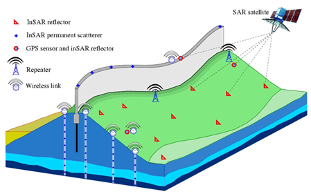
GNSS Levee Health Monitoring


© 2013 Gemini Navsoft Technologies Inc. - All rights reserved.

This website is optimized for Google Chrome, Mozilla Firefox and Apple Safari.